"GeoPostcodes has helped us enrich our internal data with accurate coordinates for postal code matching on a global basis. We calculate distances between the customer’s home address and different event venues to calculate event relevance and optimize marketing activities and spending."
Dr. Timo
Head of Customer Analytics & Campaign Management, Eventim
Self-hosted
Self-hosted delivery for enhanced security, compliance, and performance at a fixed cost, no matter the volume.
"We replaced costly APIs and simplified our location data management thanks to GeoPostcodes. Life without it would be complicated."
Nick Beaugié
Senior Software Engineer, Randstad
Multi-language support
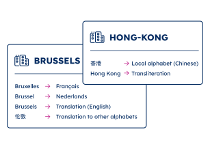
All official address names across 299 languages, including local languages, foreign names, English, and transliterations into the Roman alphabet.
"Our users value the completeness of the data, and its multi-language features. Working in a country with 3 official languages, GeoPostcodes helps us cover the needs of our patients who can input city names in English, French, or Dutch."
Antoine Pairet
CTO, Rosa
Comprehensive city definitions
Standard city definitions and classifications, including OECD metropole, capital, primary city, suburbs, and relative importance.
"A city could receive different names or belong to different hierarchical levels depending on the country. Switching to GeoPostcodes’ cities database clarified the city concept and aligned with our customers’ expectations, saving us computation time."
Kousha Mazloumi
Director of Data Science, Brizo
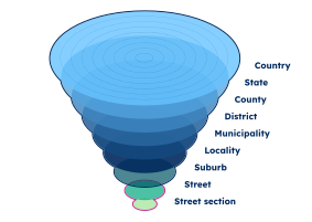
Administrative divisions
Comprehensive list of administrative levels per country, integrated into our data with regions up to 4 levels.
"We needed a global locations structure covering places and administrative divisions; after building one with GeoNames, we found limitations, especially around postal code coverage. Ultimately, we decided to base our taxonomy entirely on GeoPostcodes’ curated data for admin divisions and postal codes."
Nick Beaugié
Senior Software Engineer, Randstad
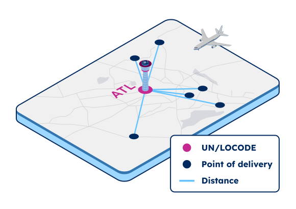
UNLOCODE and IATA codes
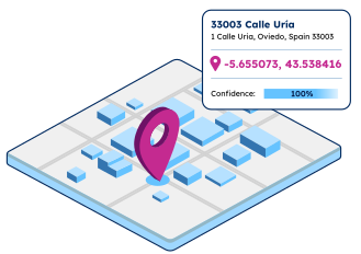
A clean list of geocoded Logistics locations associated with their closest ZIP codes and cities.
"GeoPostcodes provides complete sets, which means IATA, codes, UNLOCODEs, addresses, and so on, and that on a global scale. These codes are essential for our sea, air, and ferry calculations."
Dr. Peter Wild
Managing Partner at CarbonCare
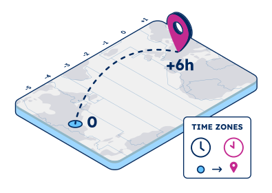
Time zones and DST
A complete list of time zones for each ZIP code and city in the world. Future and past dates of Daylight Saving Time changes worldwide are also provided.
Use cases for the international ZIP code database
Powering enterprise solutions and product innovation for businesses worldwide
Join more than 100 enterprise clients who trust GeoPostcodes for their location data
“GeoPostcodes' global ZIP codes allow us to determine distances accurately. Thanks to their up-to-date database, we no longer have problems with missing locations, making our system much more efficient and reliable.”
Anjo Grebe
Consultant
“The concept of the city receives different names or belongs to different hierarchical levels depending on the country. Using GeoPostcodes' data gave us access to city definitions aligned with our customers' expectations, saving us computation time.”
Kousha Mazloumi
Director of Data Science
“GeoPostcodes' multi-level boundaries were perfectly aligned, enabling seamless integration with multiple secure cloud platforms. Our software can now provide more accurate visualizations for risk analysis and natural hazard monitoring.”
Dave Hamm
Project Manager
“GeoPostcodes databases provide IATA codes, enhanced UNLOCODEs with port terminal data, addresses, and more – all on a global scale! This level of accuracy is essential for our mileage and CO2 emissions calculation.”
Dr. Peter Wild
Managing Partner
“The world is constantly changing. New localities and neighborhoods open up or become dispersed. It's good to know that GeoPostcodes is keeping on top of those changes and providing us with updated information to work with.”
William Chao
Product Owner of Geographic Information Services
“Countries like Brazil or China are particularly strict with their customs validation. GeoPostcodes' ZIP codes and Enhanced UNLOCODES database are aligned with national regulations, ensuring seamless transportation and compliance.”
Kavian Ranjbar
Data Governance Specialist
“GeoPostcodes' Population data shows population forecasts over the next years. We can use it as a proxy to justify longer-term changes and downgrade postal code areas in terms of economic viability.”
Kousha Mazloumi
Director of Data Science
“The key aspect of working with GeoPostcodes has been their ability to provide customized data solutions. Their collaborative approach has made them an excellent partner in addressing our location data challenges.”
Kate Kilby
Senior Product Manager
“If you've got a business where locations are a big part of it and you're looking to avoid the large costs that can be involved in using APIs, GeoPostcodes' on-premise database is definitely worth considering.”
The GeoPostcodes’ Postal database covers the whole world with a standard structure. It includes data from all other countries than USA, which USPS covers. USPS does not deliver an exhaustive database of addresses nor postal codes in the USA, but only tools to verify postal codes or addresses.
Other vendors collect USPS information and resell it. The GeoPostcodes Postal database differs from that USA data by all the features and services detailed above, for instance, the multi-lingual support, the geocodes and the timezone information.
What does ZIP code mean?
A ZIP Code is a numerical system consisting of 5 digits utilized by the United States Postal Service (USPS) to facilitate the sorting and delivery of letters to their intended destinations. The term “ZIP” stands for “Zone Improvement Plan.”
In other countries, the terms “postal code”, “postcode” or “pin code” are also used. ZIP code data plays a crucial role in various business operations within the United States, serving as a vital parameter for mailing, fraud detection, and demographic research tasks.
How big is a ZIP code database?
The size of a ZIP code database can vary depending on the level of detail and the amount of information it contains. A 5-digit ZIP codes database and their corresponding city or location names would typically be relatively small in size, usually measured in kilobytes (KB) or megabytes (MB).
However, more comprehensive ZIP code databases can include additional data such as coordinates, county names, state codes, and other geographical attributes. These databases can grow significantly in size, ranging from several megabytes to gigabytes, depending on the extent of information they provide.
What's a billing ZIP code?
A billing ZIP code is a numerical code to identify the location of the address associated with a credit or debit card. When making a purchase or transaction online or in person, merchants often require customers to provide their billing ZIP code as a security measure to verify the authenticity of the card.
By matching the provided billing ZIP code with the one associated with the card on file, merchants can reduce the risk of fraudulent transactions.
How many US ZIP codes are there?
As of today, there are more than 40,000 ZIP codes in the United States. Please note that ZIP codes can be added, modified, or removed over time due to population changes, urban development, and other factors.
Is postal code the same as ZIP code?
While “postal code” and “ZIP code” generally refer to the same concept in the United States, be aware that the terminology and format may differ in other countries. The term “postcode” is common in the United Kingdom, Australia, the Netherlands, and Germany, while “postal code” is generally used in the rest of the world, such as in Asia. In India, the most common term used is “pin code”.
How do ZIP codes work?
The five-digit ZIP code represents delivery points throughout the United States (incl. PO boxes) and is composed of three main parts: the National Area, Region or City, and Delivery Area. Additionally, USPS has divided the entire country into 10 ZIP Code areas, numbered 0-9, starting from the northeast. The first digit of the ZIP code indicates the state to which the mailer should be sent.
What is the difference between ZIP Code and ZIP Code tabulation area?
A ZIP Code is a postal code used by the USPS to identify specific mail delivery areas.
It denotes precise geographic locations for mail sorting and delivery. ZIP Code Tabulation Areas (ZCTA) are statistical entities created by the Census Bureau (American Community Survey) based on aggregating census blocks sharing the same predominant ZIP Code. It’s used for census data reporting and demographic analysis.
In essence, a ZIP Code refers to a postal area for mail delivery, while a ZCTA is a statistical approximation of that area used for census and data analysis purposes.
Why should I trust these data?
For the past 15 years, we’ve mapped the world ZIP codes, saving you the effort. Over the years, we’ve gathered valuable knowledge, enabling us to create the most complete and accurate ZIP code database in the world. Our database is curated from 1,500 authoritative sources, and is regularly updated by our data specialists to reflect the world’s changing geography.
How do our Database Subscriptions work?
Our databases are available through an annual license. This license covers the full right to use our data. It also includes full access to product updates and support. Our Enterprise and Product Licenses also come with several days of integration help included.
How much does GeoPostcodes database cost?
The cost of our database depends on the geographical coverage your use case requires. Additional datasets can also be included.
To receive additional information and an offer tailored to your needs, please contact us via our request quote page.